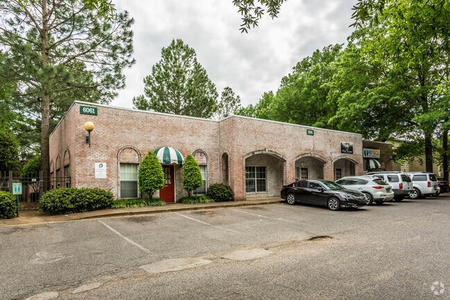
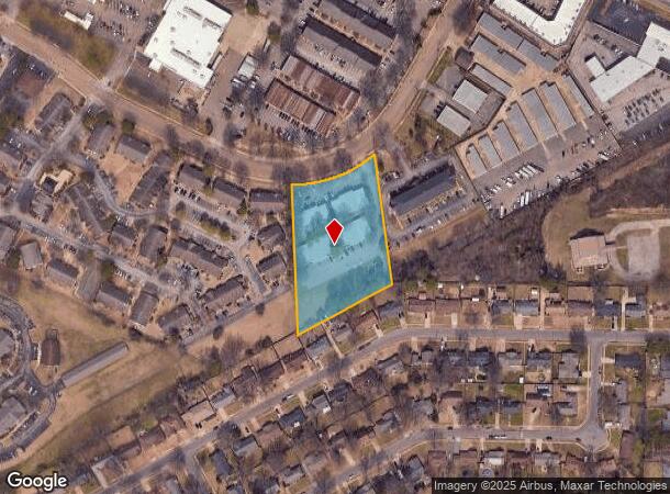
Property Record
6069 Apple Tree Dr, Memphis, TN 38115

NEARBY LISTINGS FOR SALE OR LEASE
Property Detail
6069 Apple Tree Dr
09-3100-0-0091
Apple Orchard C-P Outline/Final Plan
Officebuilding
SS APPLE TREE DR
X
Shelby
47157C0455F
Tennessee
2024
2.44 AC
2025
385 Corridor
021721
Memphis
22,784 SF
Memphis, TN-MS-AR
DEMOGRAPHICS near 6069 Apple Tree Dr
1 Mile
3 Mile
5 Mile
2024 Total Population
15,415
97,951
202,875
2029 Population
15,295
96,120
198,994
Pop Growth 2024-2029
(0.78%)
(1.87%)
(1.91%)
Average Age
34
36
38
2024 Total Households
6,562
38,917
79,906
HH Growth 2024-2029
(0.78%)
(1.89%)
(1.96%)
Median Household Inc
$39,538
$52,548
$60,990
Avg Household Size
2.30
2.40
2.50
2024 Avg HH Vehicles
1.00
2.00
2.00
Median Home Value
$149,292
$185,890
$226,238
Median Year Built
1978
1976
1977
Nearby Places
Map Layers
Map Styles
 Street
 Aerial
- Restaurants
- Banks
- Shops
- Fitness
- Groceries
PUBLIC TRANSPORTATION
AIRPORT
Memphis International
DRIVE
WALK
Distance
Memphis International
17 min
9.2 mi
Nearby Properties
Address
Land Use
TOTAL SIZE
Lot Size
Zoning
Address
Land Use
TOTAL SIZE
Lot Size
Zoning
209,070 SF
5.10 AC
RU-3
Address
Land Use
TOTAL SIZE
Lot Size
Zoning
1,082,619 SF
34.67 AC
CMP-1
Address
Land Use
TOTAL SIZE
Lot Size
Zoning
290,566 SF
2.51 AC
R-15
Address
Land Use
TOTAL SIZE
Lot Size
Zoning
451,249 SF
24.28 AC
RU-2
Address
Land Use
TOTAL SIZE
Lot Size
Zoning
704,564 SF
28.30 AC
EMP
Address
Land Use
TOTAL SIZE
Lot Size
Zoning
358,595 SF
3.65 AC
R-15
Address
Land Use
TOTAL SIZE
Lot Size
Zoning
237,911 SF
21.38 AC
EMP
Address
Land Use
TOTAL SIZE
Lot Size
Zoning
169,769 SF
3.13 AC
OG-1
Address
Land Use
TOTAL SIZE
Lot Size
Zoning
104,337 SF
7.30 AC
R-15
Address
Land Use
TOTAL SIZE
Lot Size
Zoning
101,654 SF
6.61 AC
R-15
Address
Land Use
TOTAL SIZE
Lot Size
Zoning
657,276 SF
10.18 AC
OG
Address
Land Use
TOTAL SIZE
Lot Size
Zoning
419,065 SF
19.92 AC
EMP
Address
Land Use
TOTAL SIZE
Lot Size
Zoning
2,505 SF
52.59 AC
R-10
Address
Land Use
TOTAL SIZE
Lot Size
Zoning
262,984 SF
8.09 AC
R-TH
Address
Land Use
TOTAL SIZE
Lot Size
Zoning
99,554 SF
3.26 AC
R-15
Address
Land Use
TOTAL SIZE
Lot Size
Zoning
109,774 SF
8.80 AC
CMU-1
Address
Land Use
TOTAL SIZE
Lot Size
Zoning
38,488 SF
5.68 AC
CMU-1
Address
Land Use
TOTAL SIZE
Lot Size
Zoning
269,022 SF
23.76 AC
RU-3
Address
Land Use
TOTAL SIZE
Lot Size
Zoning
51,600 SF
24.06 AC
RU-3
Address
Land Use
TOTAL SIZE
Lot Size
Zoning
66,067 SF
3.01 AC
CMU-3
Address
Land Use
TOTAL SIZE
Lot Size
Zoning
145,980 SF
16.50 AC
RU-3
Address
Land Use
TOTAL SIZE
Lot Size
Zoning
48,768 SF
7.51 AC
R-8
Address
Land Use
TOTAL SIZE
Lot Size
Zoning
113,826 SF
29.01 AC
RU-3
Address
Land Use
TOTAL SIZE
Lot Size
Zoning
96,768 SF
7.98 AC
OG
Address
Land Use
TOTAL SIZE
Lot Size
Zoning
261,479 SF
5.50 AC
RU-3
Address
Land Use
TOTAL SIZE
Lot Size
Zoning
176,176 SF
26.62 AC
R-8
Address
Land Use
TOTAL SIZE
Lot Size
Zoning
259,286 SF
12.76 AC
RU-3
Address
Land Use
TOTAL SIZE
Lot Size
Zoning
130,111 SF
5.95 AC
R-15
Address
Land Use
TOTAL SIZE
Lot Size
Zoning
77,965 SF
4.89 AC
OG
Address
Land Use
TOTAL SIZE
Lot Size
Zoning
592,766 SF
26.76 AC
EMP
The World's #1 Commercial Real Estate Marketplace
Connect with us
© 2025 CoStar Group
The information above has been obtained from sources believed reliable. While we do not doubt its accuracy we have not verified it and make no guarantee, warranty or representation about it. It is your responsibility to independently confirm its accuracy and completeness. Any projections, opinions, assumptions, or estimates used are for example only and do not represent the current or future performance of the property. The value of this transaction to you depends on tax and other factors which should be evaluated by your tax, financial, and legal advisors. You and your advisors should conduct a careful, independent investigation of the property to determine to your satisfaction the suitability of the property for your needs.